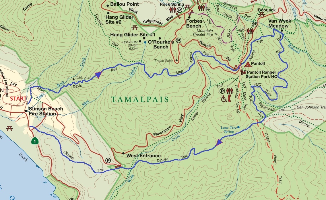
Stinson Beach (0.4) -- Matt Davis (1.8+1.2) -- (Pantoll Ranger Station ì ì¬) -- Alpine (0.5+0.2+0.2) --Troup 80 (0.1)  -- TCC (0.9+0.4)Â
-- DipSea (0.1+1.4+0.9) -- (0.4) = 8.5 Mile
Prevì´ì 문ì
Nextë¤ì 문ì
| ì°íë ì | 2019-06-29 |
|---|---|
| ì§ì | Marin |
| ì¥ì | Mount Tamalpais SP ã ¡ Matt Davis Trail |
| ëì´ë | Moderately Strenuous (ì½ê° íë¦) |
| ìì 거리 (mi) | 8.5 |
| ê³ ë ë³í (ft) | 1600 |
| ìì ìììê° (hr) | 5 |
| 모ì´ë ìê° ë° ì¥ì | 2ì°¨ ì§ê²°ì§ ì£¼ì°¨ì¥ @ 9:00 AM |
| 구굴 ì§ë | https://goo.gl/maps/smRqUnQrkMT2 |
| 길 ì¤ëª / ì¤ë¹ë¬¼ | 2ì°¨ ì§ê²°ì§ : Stinson Beach Federal Park ì£¼ì°¨ì¥ 10 Marine Way, Stinson Beach, CA 94970 (ì¢í: 37.897313, -122.639803) US-101 ìì CA-1 N (Exit 445B ) ì¶êµ¬ë¡ ëê° CA -1 N ì¼ë¡ Stinson Beach 쪽ìí¥í´ 12.5 ë§ì¼ ê°ëë¤ Stinson Beach ëë¤ìì Marine Wayë¡ ì¢íì íë©´ ì¤í´ì¨ ë¹ì¹ ê³µì 주차ì¥ì´ ì¼í¸ì¼ë¡ ììµëë¤. |
| ë¹ìì°ë½ | 408-891-7274 |
| ë ì¨ | https://weather.com/weather/tenday/l/CASPMTTM:13:US |

Stinson Beach (0.4) -- Matt Davis (1.8+1.2) -- (Pantoll Ranger Station ì ì¬) -- Alpine (0.5+0.2+0.2) --Troup 80 (0.1)  -- TCC (0.9+0.4)Â
-- DipSea (0.1+1.4+0.9) -- (0.4) = 8.5 Mile


Hi Panda, I'll.
I'll have a great trip to Alaska.
Yes, I'll enjoy the sea, relax and take excellent pictures.
I'll also wait for my side to face the glacier and capture the moment for some ice to fall to the sea.
I'll make sure to get water bottles filled up and take them to excursions.
And, I'll think of you and your map on every single Saturday I miss.
Foremost, I'll remember you, a great human being with thoughtful mind and warm smile, in the rest of my life...
I wish you all the best until we meet again in about three weeks.
Have a wonderful day!
-Hodham


ì°¸ê°í©ëë¤ (5 ë²)
ì²íë ì¹´í ê°ì¬í©ëë¤


ì ë ì°¸ìí©ëë¤.Â


| ë²í¸ | ì§ì | ì°íë ì | ë¶ë¥ | ì 목 | ë ì§ | ê¸ì´ì´ | ì¡°í ì |
|---|---|---|---|---|---|---|---|
| 666 | North Bay | 2025-04-26 | ì¼ë° |
4ì 26ì¼ Point Reyes - Limantour Beach TH
4 |
2025.04.17 | ì½ë¡ | 125 |
| 665 | Sacramento | 2025-04-19 | ì¼ë° |
4ì 19ì¼ North Table Mountain Ecological Reserve
25 |
2025.04.13 | ì°ë³´ | 404 |
| 664 | South Bay | 2025-04-12 | ì¼ë° |
Pinnacles NP 4ì 12ì¼
24 |
2025.04.04 | ì쪽길 | 560 |
| 663 | East Bay | 2025-04-05 | ì 기 |
4ì5ì¼ ì 기ì´í / 창립기ë
/ ì 기ì°í
37 |
2025.03.26 | SK | 991 |
| 662 | North Bay | 2025-03-29 | ì¼ë° |
3ì29ì¼ ììì´í / Marin Headlands (Costal Trail, Miwok Trail, and Bonita Lighthouse Loop)
28 |
2025.03.23 | SK | 808 |
| 661 | East Bay | 2025-03-22 | ì¼ë° |
Tilden Regional Park - Seaview, Meadow Canyon
25 |
2025.03.18 | bear | 663 |
| 660 | South Bay | 2025-03-22 | ì¼ë° |
Butano State Park
8 |
2025.03.17 | ì°°ë¼ | 531 |
| 659 | Sacramento | 2025-03-22 | ì¼ë° |
Coloma - Cronan Ranch West Ridge Trail via Gerle Loop
7 |
2025.03.18 | SK | 416 |
| 658 | South Bay | 2025-03-15 | ì¼ë° |
3/15/25 Huddart CP
26 |
2025.03.09 | 무ì§ê° | 818 |
| 657 | North Bay | 2025-03-15 | ì¼ë° |
Mt. Tamalpais
18 |
2025.03.11 | ì°°ë¼ | 702 |
ë무꾼ëì ì¡°í¬ë¥¼ ë¹ë ¤ì "ì ë¬¼ë¡ ìë¼ì¤ì¹´ ë¹í ê°ì ¸ ì¬ê²ì. ë ¹ìì ë¬¼ì´ ëê² ì§ë§ ê·¸ëë ìë¼ì¤ì¹´ ë¹íë¬¼ë§ íë² ë³´ì¸ì :)"